Part 107 sectional chart questions on current charts
16 free here, 87 in the Part 107 Charts Pack, $19 once. Every answer checked against FAA data.
Which frequency is the Common Traffic Advisory Frequency (CTAF) at MILLVILLE MUNI (MIV)?
What the new chart questions look like on the real test
Three test-taker reports so far (October 27, 29 and 30, 2026): 3 to 10 chart questions each. One saw mostly Testing Supplement figures (Minot among them); one had 2 supplement figures and 3 charts never seen before, asking surface airspace under shaded magenta, a lighted tower's height and obstacles near a point; the third (scored 100%) had at least 3 cropped-chart questions, two of them asking which airspace a small magenta airport with no markings sits in; the crops also asked a CTAF frequency and what to do when shooting real-estate photos near an airport, and a wider sectional asked the airspace 400 feet above a tower you had to inspect (Class C, authorization required). The supplement figures are explained one by one here, so practice both. New to sectionals? Read the worked example first.
All 16 free chart questions, with answers and the FAA data behind them
The same questions as the drill above, as a list you can print or study offline. Try each one before you open the answer. Every answer was checked against the FAA dataset named under it (Oct 29, 2026 sectionals).
1. Which frequency is the Common Traffic Advisory Frequency (CTAF) at MILLVILLE MUNI (MIV)?
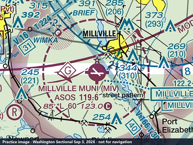
- A. 123.0 MHz
- B. 119.6 MHz
- C. 122.2 MHz
Show the answer
A. 123.0 MHz In the MIV data block, the frequency followed by the C in a circle is the CTAF: 123.0. ASOS 119.6 is the automated weather broadcast, and 122.2 is a Flight Service frequency printed in the box to the right.
Checked against: FAA NASR 28-day subscription, FRQ.csv (CTAF), MIV CTAF 123.0 (NASR cycles effective Sep 3 and Oct 1, 2026 (same value in both)). ACS UA.V.B.K6a.
2. What is the ceiling of the Class D airspace at FREDERICK MUNI (FDK)?
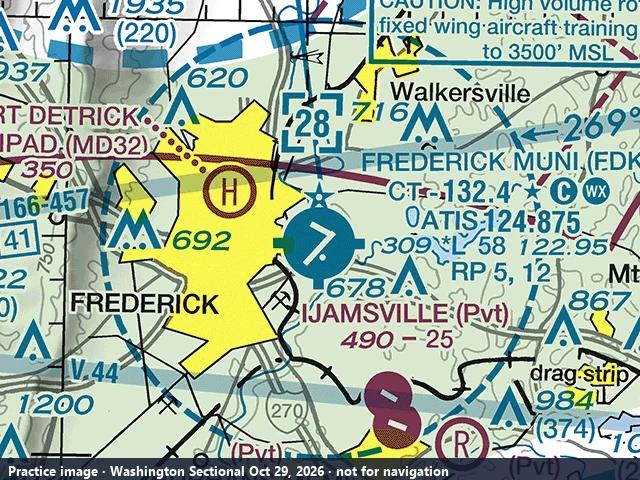
- A. 2,800 feet AGL
- B. 2,800 feet MSL
- C. 2,500 feet MSL
Show the answer
B. 2,800 feet MSL The number in the dashed blue box, [28], is the Class D ceiling in hundreds of feet MSL: 2,800 feet MSL. Class D altitudes on a sectional are always MSL, not AGL.
Checked against: FAA Class Airspace shapefile (NASR 2026-10-01), FDK CLASS_D UPPER_VAL=2800 MSL (Class Airspace shapefile, NASR subscription effective Oct 1, 2026). ACS UA.II.A.K1c.
3. What class of airspace surrounds BREMERTON NTL (PWT) down to the surface?
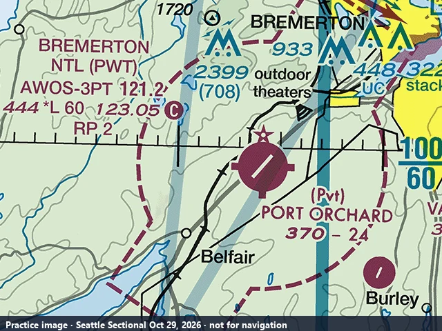
- A. Class E
- B. Class D
- C. Class G
Show the answer
A. Class E The dashed magenta circle around the airport marks Class E airspace that begins at the surface. Operating a small UA in it requires ATC authorization (for example through LAANC).
Checked against: FAA NASR 28-day subscription, CLS_ARSP.csv, PWT CLASS_E_AIRSPACE=Y (NASR cycles effective Sep 3 and Oct 1, 2026 (same value in both)). ACS UA.II.A.K1d.
4. In the Las Vegas Class B sector labeled 100 over 45, where does the Class B airspace begin and end?
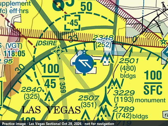
- A. Surface to 10,000 feet MSL
- B. 4,500 to 10,000 feet MSL
- C. 4,500 to 10,000 feet AGL
Show the answer
B. 4,500 to 10,000 feet MSL Class B labels give the ceiling over the floor in hundreds of feet MSL: 100 over 45 is 4,500 to 10,000 feet MSL. Below 4,500 feet MSL in that sector you are not in the Class B.
Checked against: FAA Class Airspace shapefile (NASR 2026-10-01), LAS CLASS_B sector 4500-10000 MSL (Class Airspace shapefile, NASR subscription effective Oct 1, 2026). ACS UA.II.A.K1a.
5. What is the frequency of the WENATCHEE VOR/DME in the box at the top right of the image?
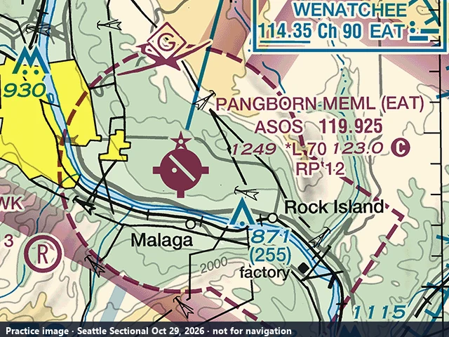
- A. 119.925 MHz
- B. 90.0 MHz
- C. 114.35 MHz
Show the answer
C. 114.35 MHz The box reads WENATCHEE 114.35 Ch 90 EAT: 114.35 MHz is the VOR frequency and Ch 90 the paired DME channel.
Checked against: FAA NASR 28-day subscription, NAV_BASE.csv (FREQ), EAT VOR/DME FREQ=114.35 (NASR cycles effective Sep 3 and Oct 1, 2026 (same value in both)). ACS UA.V.B.K6a.
6. What is the control tower frequency at HENDERSON EXEC (HND)?
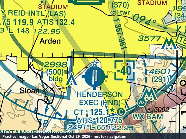
- A. 125.1 MHz
- B. 120.775 MHz
- C. 122.95 MHz
Show the answer
A. 125.1 MHz CT - 125.1 is the tower frequency (part-time, star). 120.775 is ATIS and 122.95 UNICOM.
Checked against: FAA NASR 28-day subscription, FRQ.csv (LCL/P), HND LCL/P 125.1 (NASR cycles effective Sep 3 and Oct 1, 2026 (same value in both)). ACS UA.V.B.K6a.
7. What kind of airspace is labeled R-6714D near the top of the image?
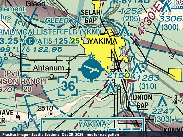
- A. A Military Operations Area
- B. A recreational flight area
- C. A Restricted Area
Show the answer
C. A Restricted Area An R- prefix marks a Restricted Area. While it is active, no aircraft, drones included, may operate inside it without permission from the using or controlling agency (14 CFR 73.13). MOAs are labeled with the word MOA, not an R- number.
Checked against: FAA ADDS Special Use Airspace, R-6714D TYPE_CODE=R (FAA ADDS Special Use Airspace layer, queried Oct 9, 2026). ACS UA.II.A.K2.
8. A remote pilot wants to fly at 300 feet AGL two miles from FIRST FLIGHT (FFA). Based on the chart, what airspace is at the surface there and is ATC authorization required?
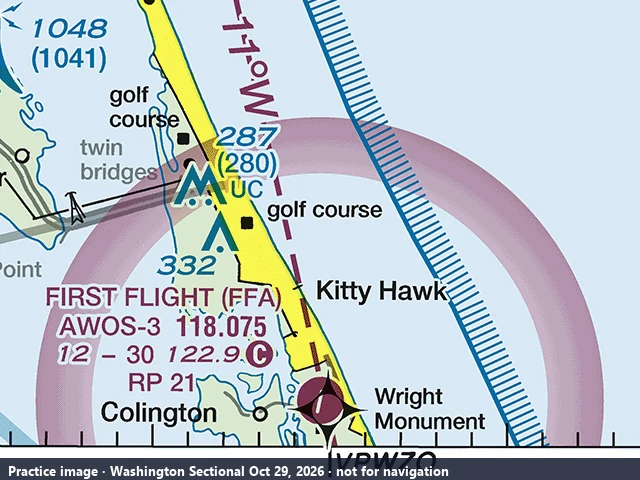
- A. Class E to the surface; authorization is required
- B. Class G; no ATC authorization is required
- C. Class D; authorization is required
Show the answer
B. Class G; no ATC authorization is required There is no dashed magenta line around FFA, only the shaded magenta vignette, which means Class E begins at 700 feet AGL and the airspace below it, where the drone flies at 300 feet AGL, is Class G. 14 CFR 107.41 requires ATC authorization only in Class B, C, D and Class E surface areas, so none is needed here (14 CFR 107.43 still applies: do not interfere with airport operations).
Checked against: FAA NASR 28-day subscription, CLS_ARSP.csv and Class Airspace shapefile (NASR 2026-10-01), FFA: no CLS_ARSP record, no surface-area polygon; lowest controlled airspace KILL DEVIL HILLS CLASS E5 floor 700 ft AGL (NASR cycles effective Sep 3 and Oct 1, 2026 (no surface-area record in either) and Class Airspace shapefile effective Oct 1, 2026). ACS UA.II.A.K1d.
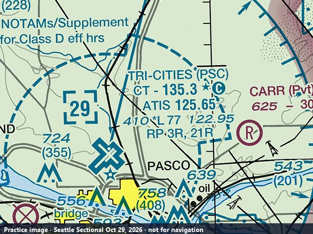
9. What is the control tower frequency at TRI-CITIES (PSC)?
- A. 135.3 MHz
- B. 125.65 MHz
- C. 122.95 MHz
Show the answer
A. 135.3 MHz The tower frequency is the one printed after CT - in the airport data block: 135.3 (part-time, star; it is also the CTAF when the tower is closed). 125.65 is ATIS and 122.95 is UNICOM.
Checked against: FAA NASR 28-day subscription, FRQ.csv (LCL/P), PSC LCL/P 135.3 (NASR cycles effective Sep 3 and Oct 1, 2026 (same value in both)). ACS UA.V.B.K6a.
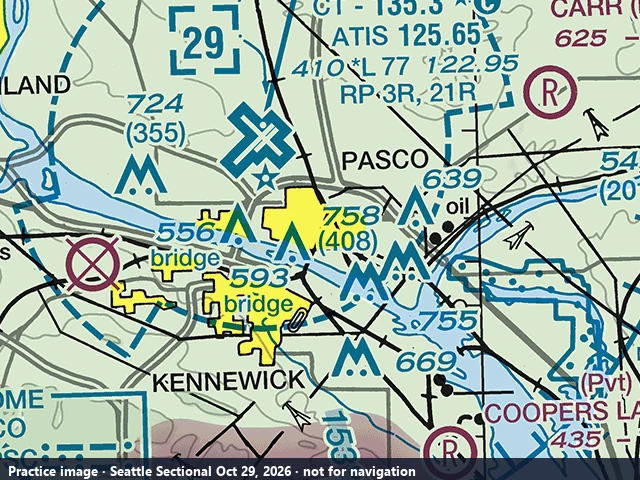
10. How tall above the ground is the obstruction labeled 758 southeast of the PSC airport symbol?
- A. 758 feet
- B. 408 feet
- C. 350 feet
Show the answer
B. 408 feet The bold 758 is the top of the obstruction in feet MSL; the 408 in parentheses below it is its height above ground level. The test asks AGL versus MSL constantly: the number in parentheses is always AGL.
Checked against: FAA Digital Obstacle File (daily DOF, 8 Oct 2026), OAS 53-020418 AGL=408 AMSL=758 (T-L TWR PASCO) (DOF daily file of Oct 8, 2026). ACS UA.V.B.K6a.
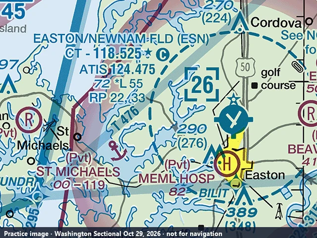
11. What is the control tower frequency at EASTON/NEWNAM FLD (ESN)?
- A. 124.475 MHz
- B. 118.525 MHz
- C. 122.95 MHz
Show the answer
B. 118.525 MHz The tower frequency follows CT in the airport data block: CT - 118.525. ATIS 124.475 is the recorded information broadcast.
Checked against: FAA NASR 28-day subscription, FRQ.csv (LCL/P), ESN LCL/P 118.525 (NASR cycles effective Sep 3 and Oct 1, 2026 (same value in both)). ACS UA.V.B.K6a.
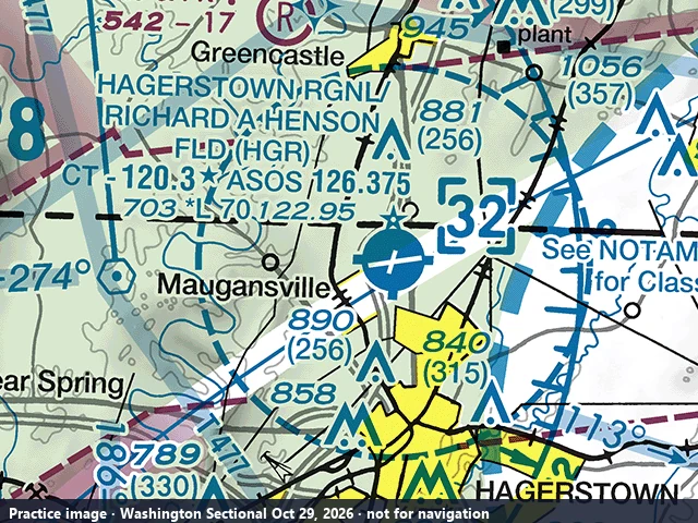
12. Up to what altitude does the Class D airspace at HAGERSTOWN RGNL (HGR) extend?
- A. 3,200 feet MSL
- B. 3,200 feet AGL
- C. 3,000 feet MSL
Show the answer
A. 3,200 feet MSL [32] in the dashed blue box is the Class D ceiling: 3,200 feet MSL.
Checked against: FAA Class Airspace shapefile (NASR 2026-10-01), HGR CLASS_D UPPER_VAL=3200 MSL (Class Airspace shapefile, NASR subscription effective Oct 1, 2026). ACS UA.II.A.K1c.
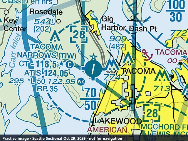
13. What is the ceiling of the Class D airspace around TACOMA NARROWS (TIW)?
- A. 5,000 feet MSL
- B. 2,800 feet AGL
- C. 2,800 feet MSL
Show the answer
C. 2,800 feet MSL The dashed blue Class D circle carries [28]: its ceiling is 2,800 feet MSL. The 70 over 50 nearby is a Seattle Class B shelf (5,000 to 7,000 feet MSL), not the Class D.
Checked against: FAA Class Airspace shapefile (NASR 2026-10-01), TIW CLASS_D UPPER_VAL=2800 MSL (Class Airspace shapefile, NASR subscription effective Oct 1, 2026). ACS UA.II.A.K1c.
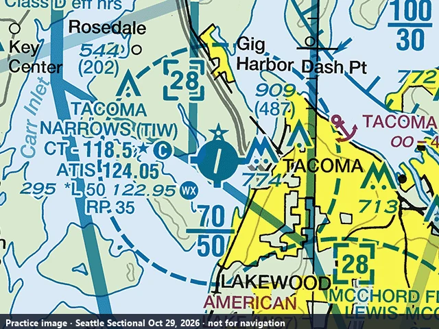
14. You are hired to inspect the tower charted 909 (487) northeast of TACOMA NARROWS (TIW) and plan to fly 400 feet above its top while the TIW control tower is operating. In what airspace will you be operating, and is ATC authorization required?
- A. Class D airspace; ATC authorization is required
- B. Class E airspace; no authorization is required because 14 CFR 107.51 allows 400 feet above a structure
- C. Class B airspace; the Seattle Class B shelf begins at the top of the tower
Show the answer
A. Class D airspace; ATC authorization is required The tower top is 909 feet MSL, so 400 feet above it is 1,309 feet MSL, an altitude 14 CFR 107.51(b) permits within 400 feet of the structure. The tower stands inside the dashed blue TIW Class D surface area, whose ceiling is 2,800 feet MSL ([28]), so you are in Class D and need ATC authorization under 14 CFR 107.41; 107.51(b) never waives that. The Seattle Class B shelf over this area does not begin until 5,000 feet MSL.
Checked against: FAA DOF (daily, downloaded Oct 9, 2026) + FAA Class Airspace shapefile (NASR Oct 1, 2026), DOF OAS 53-000029 TOWER TACOMA 47.278749 -122.512894 AGL 487 AMSL 909; point inside TACOMA CLASS D SFC-2800 MSL and under SEATTLE CLASS B 5000-10000 MSL. 909+400 = 1,309 MSL < 2,800 (D ceiling) and < 5,000 (B floor). TIW Class D hours 0800-2000; otherwise Class E surface area (authorization still required). (Sectionals edition Oct 29, 2026 (answer re-checked; unchanged since Sep 3, 2026); Class Airspace NASR Oct 1, 2026; DOF Oct 9, 2026). ACS UA.II.A.K1c.
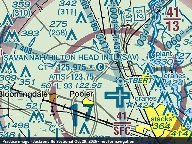
15. Near SAVANNAH/HILTON HEAD INTL (SAV), the magenta Class C sector in the upper right is labeled 41 over 13. Between which altitudes does the Class C airspace extend there?
- A. Surface to 4,100 feet MSL
- B. 1,300 to 4,100 feet MSL
- C. 1,300 to 4,100 feet AGL
Show the answer
B. 1,300 to 4,100 feet MSL Class C numbers are in hundreds of feet MSL: the top number (41) is the ceiling and the bottom number (13) is the floor, so this outer sector runs from 1,300 to 4,100 feet MSL. Surface to 4,100 feet MSL is the inner sector labeled 41 over SFC next to the airport, and these sectional altitudes are MSL, not AGL.
Checked against: FAA NASR 28-day subscription, Class Airspace shapefile (Class_Airspace.shp) and CLS_ARSP.csv, SAVANNAH INTL AIRPORT CLASS C (SAV): outer sector LOWER 1300 FT MSL / UPPER 4100 FT MSL; surface sector SFC / 4100 FT MSL; CLS_ARSP SAV CLASS_C_AIRSPACE=Y (Jacksonville Sectional Oct 29, 2026; NASR cycle effective Oct 29, 2026). ACS UA.II.A.K1b.
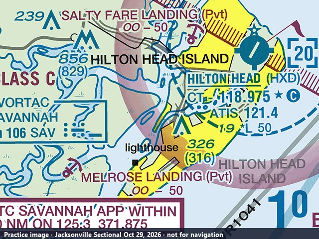
16. Which frequency is the Common Traffic Advisory Frequency (CTAF) at HILTON HEAD (HXD)?
- A. 118.975 MHz
- B. 121.4 MHz
- C. 125.3 MHz
Show the answer
A. 118.975 MHz In the HXD data block, CT - 118.975 is the tower frequency; the star means the tower is part-time and the C in a circle means 118.975 is also the CTAF when the tower is closed. 121.4 is the ATIS on the line below, and 125.3 is the Savannah Approach frequency in the CTC SAVANNAH APP box at the lower left.
Checked against: FAA NASR 28-day subscription, FRQ.csv (CTAF), HXD CTAF 118.975 (LCL/P 118.975 0700-2100; ATIS 121.4); SAV APCH/P DEP/P 125.3 serving HXD (Jacksonville Sectional Oct 29, 2026; NASR cycle effective Oct 29, 2026). ACS UA.V.B.K6a.
Want more on current charts? The Sectional Chart Questions Pack adds the rest, and the free 60-question practice test covers the whole exam.
How these questions were made
Each image is a 640 × 480 crop, at full print resolution, of a current FAA sectional chart (edition of Oct 29, 2026, public domain). We only wrote questions whose answer is fixed by FAA data, and checked every answer against it. Then a second reviewer answered each question looking only at the image, and only questions where both agreed are published: 103 so far, 16 here and 87 inside the Part 107 Pass and the Charts Pack.
| Question type | Checked against | Edition |
|---|---|---|
| Airport elevation, CTAF and tower frequencies | FAA NASR airport (APT) and frequency (FRQ) files | Cycle of Oct 29, 2026 |
| Class B, C and D floors and ceilings | FAA Class Airspace data (NASR) | Subscription effective Oct 1, 2026 |
| Class E to the surface | FAA NASR class airspace (CLS_ARSP) file | Cycle of Oct 29, 2026 |
| Obstacle heights (MSL and AGL) | FAA Digital Obstacle File (DOF), verified obstacles | Daily file of Oct 8, 2026 |
| VOR frequencies | FAA NASR navaid (NAV) file | Cycle of Oct 29, 2026 |
| Restricted areas | FAA Special Use Airspace data (ADDS) | Queried Oct 9, 2026 |
Practice images only, not for navigation. The FAA's own warning about the real test applies: “Once an image is embedded in a test question, it becomes an integral part of that question. Consequently, the specific images used in active test questions cannot be previewed, as doing so would compromise the exam's integrity.” (FAA advisory, p. 5). Found an answer you think is wrong? Tell us at hello@rotatepilot.com and we take the question down within 24 hours while we check it.
Frequently asked questions
Are these the real FAA Part 107 test questions?
No. They are practice in the style of the FAA's published samples. The FAA says the images used in active test questions cannot be previewed. These use crops of the current FAA sectional charts, and every answer is checked against FAA data.
What changes on the Part 107 test on October 26, 2026?
The FAA says: "Beginning October 26, 2026, the Instrument Rating Airplane (IRA) and Unmanned Aircraft General-Small (UAG) tests will include image-based questions not found in the test supplements (see examples below)." The supplement stays available at the test center until the FAA announces its removal.
How do you know each answer is right?
Each answer comes from an FAA database (airports and frequencies, class airspace, obstacles, navaids or special use airspace) and must match what is printed on the chart crop. A second reviewer then answered every question looking only at the image; questions where the two disagreed were not published.
Which sectional charts are used?
The Washington, Seattle, Las Vegas and Jacksonville (Savannah) sectionals, edition of Oct 29, 2026, downloaded from the FAA (public domain). Each image says so in its bottom strip and is marked not for navigation.
Do I still need to read the chart if I use a LAANC app?
For flying, the app tells you the ceiling at your spot. For the test, no. PSI test centers do not let you use a phone or an app at the computer: the only thing on screen is the chart image and the question. The Remote Pilot ACS (area UA.II.A) tests reading the chart itself: which airspace class a point is in, the floor and ceiling printed in the sector label, and what the symbols mean. A test-taker who sat the exam on Oct 30, 2026 reported 8 to 10 chart-image questions out of 60, and one who sat it on Oct 29 was asked twice which airspace a small magenta airport with no markings sits in (Class G up to 700 feet AGL under the shaded vignette), so the chart is worth learning for the one hour the app is not in your hand.
Written by Renzo Madueño, former Airbus A320 First Officer (Avianca), FAA commercial pilot. Last reviewed . Rotate Pilot is independent and not affiliated with the FAA or PSI. More practice: the free Part 107 practice test.